搜索
bottom↓
回复: 6

一些国外做的最简易pic32小板的资料

[复制链接]

出0入0汤圆

发表于 2010-8-6 12:03:34 | 显示全部楼层 |阅读模式
http://www.pic32.byvac.com/hw.php

http://code.google.com/p/cui32/

http://hackedgadgets.com/2008/10/28/bums-project-bathroom-utilities-management-system-pic32-based/

http://diydrones.com/profiles/blogs/pic32-autopilot-layout-done

http://www.vexforum.com/gallery/showimage.php?i=1746

http://www.mypic32.com/web/guest/contestants

http://www.element-14.com/community/docs/DOC-20175

出0入0汤圆

发表于 2010-8-6 20:13:02 | 显示全部楼层

出0入0汤圆

发表于 2010-8-7 12:29:58 | 显示全部楼层
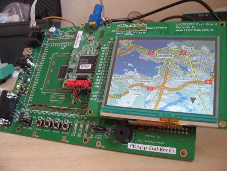
http://www.mypic32.com/web/guest/contestantsprofiles?profileID=24826

Nowdays stealing of cars is a great problem. Unfortunately, car alarm systems, which are in circulation gives not enough security. In my project I try to update these systems with following functions:
- remote control on/off function (sms)
- You can query the alarm system on/off status (sms)
- at anytime You can query the car GPS position with a simply sms message
- in case of alarm-signal the system send a warning sms
- You can download the cameras picture which is situated in car (with software by means of GPRS)
- You can follow on-line the car movement ( with software through GPRS)


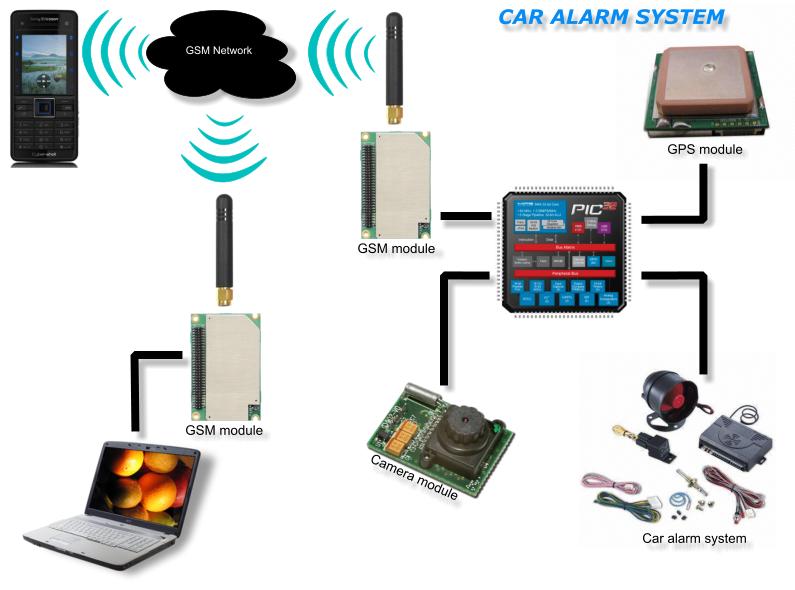
(原文件名:24826-1216065253958-CarAlarm.jpg)

出0入0汤圆

发表于 2010-8-7 12:31:37 | 显示全部楼层
我知道的实际产品是用别的主控做的,用的是别的移动网络供应商的模块,没有摄像头。在公交上使用

出0入0汤圆

 楼主| 发表于 2010-8-17 10:35:02 | 显示全部楼层
http://mehilainen.homeip.net/mapviewer/mapviewer.html
Project MapViewer

The idea of this project was to build a device that can scroll map picture on LCD screen automatically depending of coordinates from GPS module. User can also scroll map picture manually using touchscreen. PIC32MX360F512L is used as main processor and Solomon Systech SSD1928 is an image processor that actually controls 3.5" QVGA LCD screen. There’s also JPEG codec and SD card interface on SSD1928. Map pictures are saved to Micro SD card.

Here’s hardware I used in this project. PIC32 evaluation board and LCD module with SSD1928 chip onboard from techtoys.com.hk. There’s also a GPS module in the middle connected to PIC32’s UART1. PIC and SSD1928 are connected together through 8-bit parallel port and touchscreen is connected to PIC’s AD converter. There’s also Micro SD card socket that is wired directly to SSD1928 on the LCD module board.

I grabbed map picture from Google Maps with this handy software and then converted it from PNG to JPEG. At the moment I have made map only for my hometown Tampere with five zoom levels (11 – 15 levels on Google Maps). The position on the map can be calculated like this:
x = (GPS longitude - top left longitude of the map) / longitude degree per pixel
y = (top left latitude of the map - GPS latitude) / latitude degree per pixel

Here’s the video where I’m scrolling and zooming the map. Holding the finger on the touchscreen for one second will zoom in and double click will zoom out the map.

(原文件名:IMG_5761_small.jpg)

出0入0汤圆

发表于 2010-8-17 14:19:33 | 显示全部楼层
顶!!!!!

出0入0汤圆

发表于 2010-8-30 21:10:04 | 显示全部楼层
mark
回帖提示: 反政府言论将被立即封锁ID 在按“提交”前,请自问一下:我这样表达会给举报吗,会给自己惹麻烦吗? 另外:尽量不要使用Mark、顶等没有意义的回复。不得大量使用大字体和彩色字。【本论坛不允许直接上传手机拍摄图片,浪费大家下载带宽和论坛服务器空间,请压缩后(图片小于1兆)才上传。压缩方法可以在微信里面发给自己(不要勾选“原图),然后下载,就能得到压缩后的图片】。另外,手机版只能上传图片,要上传附件需要切换到电脑版(不需要使用电脑,手机上切换到电脑版就行,页面底部)。
您需要登录后才可以回帖 登录 | 注册

本版积分规则

手机版|Archiver|amobbs.com 阿莫电子技术论坛 ( 粤ICP备2022115958号, 版权所有:东莞阿莫电子贸易商行 创办于2004年 (公安交互式论坛备案:44190002001997 ) )

GMT+8, 2024-5-9 01:52

© Since 2004 www.amobbs.com, 原www.ourdev.cn, 原www.ouravr.com

快速回复 返回顶部 返回列表